
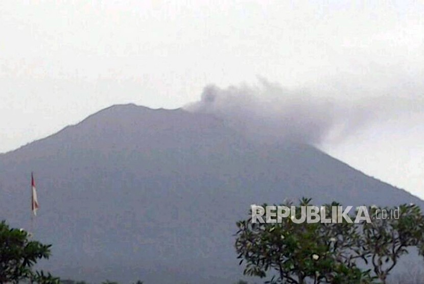
REPUBLIKA.CO.ID, DENPASAR -- The Energy and Mineral Resources Ministry's Volcanology and Geological Hazard Mitigation Center (PVMBG) reported that Mount Agung has erupted, releasing volcanic ashes and smoke from the crater.
The eruption occurred at 5.05 p.m. local time, with grey smoke rising about 700 meters from the crater.
The PVMBG Head of Volcano Supervision and Mitigation, Devy Kamil Syahbana, stated in Denpasar on Tuesday that the smoke was moving towards the eastern and southeastern regions of the volcano.
"(Despite the eruption), the volcano remained in the stage III of alert status. Hence, we hope that people would remain calm and follow the PVMBG's instructions," she remarked.
According to the official website, "magma.vsi.esdm.go.id,", people should stay alert for the imminent heavy ash rain, following the eruption, in all disaster prone-areas nearby the volcano.
The heavy ash rain is predicted to spread to the other regions outside the disaster prone-areas, depending on the wind direction and velocity.
Hence, in order to protect the people from the volcanic ash, PVMBG expressed hope that the disaster mitigation agency, along with other stakeholders, could reassess some evacuation zones established earlier.
The PVMBG has urged the evacuees and other people to always use masks to protect their nose, mouth, and eyes, as the volcanic ashes tend to severely affect the respiratory system.
Following the eruption, the PVMBG has also called on all villagers in the disaster-prone areas, the tourists, and other individuals to avoid any activities near the volcano and other regions within six kilometers radius from the crater, as well as in the areas within 7.5 kilometers to the north, northeast, southeast, south, and to the southwest of Mount Agung.
Calm
The PVMBG has asked people to remain calm and vigilant, in addition to creating few steps to anticipate the volcanic ashes.
"The locals living near the volcano, hikers, as well as tourists must stay calm and follow the information issued by the authority," Syahbana remarked in Denpasar on Tuesday.
Meanwhile, PVMBG has informed the National Disaster Mitigation Agency (BNPB), the Bali Disaster Mitigation Agency (BPBD), Karangasem Disaster Mitigation Agency, as well as other stakeholders to continue following the updates published through the "magma.vsi.esdm.go.id" official website.
Although the PVMBG has mapped some dangerous zones before the eruption, the authority could change the locations, following the updates and latest observations on the volcano.
The authority further mentioned some disaster-prone sub-villages (Br.), such as Belong, Pucang, Pengalusan (in Ban Village), Badeg Kelodan, Badeg Tengah, Badegdukuh, Telunbuana, Pura, Lebih, and Sogra (in Sebudi Village).
Other areas predicted to be affected are Br. Kesimpar, Kidulingkreteg, Putung, Temukus, Besakih, and Jugil (in Besakih Village), Br. Bukitpaon and Tanaharon (in Buana Giri Village), Yehkori, Untalan, Galih and Pesagi (in Jungutan Village), and some parts of Dukuh Village.
Also read: Emergency status of Mount Agung is extended until Nov 9
On Sept, 22 The Meteorology, Climatology and Geophysics Agency (BMKG) increased the alert status of Mount Agung to the highest IV stage, but on Oct, 29, the authority downgraded the status to the III stage.
After the government set the highest critical status of Mount Agung, some hundreds of thousands of locals were evacuated from their homes to the emergency camps located in the districts of Klungkung, Buleleng, Bangli, Gianyar, Karangasem, Badung, and Denpasar.
